Trade Routes in the Americas
Teacher Resources

Driving Question: How were different regions of the Americas connected by trade in this period?
Long-distance networks of exchange stretched across Mesoamerica, the Caribbean, the Andes, the Amazon Basin, and different regions of North America. These networks weren’t as extensive or dense as those in Afro-Eurasia. Still, people living in the Americas formed long-distance networks that carried goods, ideas, and people across continents.
Learning Objectives:
- Understand how Indigenous communities in the Americas interacted through networks of exchange in the thirteenth and fourteenth centuries.
- Compare how trade networks connected societies in the Americas, and how communities were changed by these connections.
Vocab Terms:
- dwelling
- kiva
- maize
- obsidian
- pantheon
- pochteca
- tribute
Opener: Trade Routes in the Americas
To teach this lesson step, refer to page 2 of the Lesson 6.6 Teaching Guide.
Students need a refresher on the Networks Frame? Now is a good time to rewatch the Networks Frame Introduction.
If you were a thirteenth-century trader in the Americas, what would you sell? Why? Embrace your inner merchant in this activity.
Indigenous American Trade Routes
To teach this lesson step, refer to page 3 of the Lesson 6.6 Teaching Guide.
Don’t forget that you can change the reading levels of the articles for your students. Read more on page 3 of the OER Project Reading Guide.
Long-distance trade routes moved goods, people, and ideas across every region of the Americas. Use the materials below to understand how these networks shaped Indigenous American societies, and then map out what you learn.
-
Guiding Questions
-
Before you read
Preview the questions below, and then skim the article. Be sure to look at the section headings and any images.
While you read
Look for answers to these questions:
- What were some barriers to trade in Mesoamerica?
- What made Teotihuacan an important trading center?
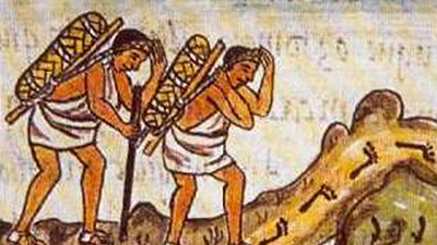
- What sort of goods traveled across long-distance routes in the Americas?
- Why don’t we know very much about merchants in Teotihuacan? Why do we know more about merchants in Tenochtitlán?
- What was life like for merchants in the Aztec Empire? What roles did they play in the empire, other than trader?
After you read
Respond to this question: Think about the region you live in. What environmental features would have made it easier or harder for you to trade with other regions if you had to carry all your trade goods on your back or in a canoe?
-
Guiding Questions
-
Before you watch
Preview the questions below, and then review the transcript.
While you watch
Look for answers to these questions:
- What sorts of buildings were constructed at Chaco Canyon and who built them?
- What are kivas and what are outliers?
- How many people lived in the Chaco Canyon region? Why did this number change?
- Why is it wrong to think of Chaco as a center?
- What sort of trade and long-distance connections did the people at Chaco Canyon have?
After you watch
Respond to these questions: How were the trade routes around Chaco Canyon similar to those in Afro-Eurasia? How were they different from them?
Closer: Trade Routes in the Americas
To teach this lesson step, refer to page 5 of the Lesson 6.6 Teaching Guide.
Looking for more maps? Check out OER Project’s collection of maps here.
Build on your mapping skills and think more broadly about how networks of exchange shaped American communities.
The Caribbean
To teach this lesson step, refer to page 5 of the Lesson 6.6 Teaching Guide.
The Caribbean was an important part of a growing center of trade for Indigenous Americans in the precolonial era.
-
Guiding Questions
-
Before you watch
Preview the questions below, and then review the transcript.
While you watch
Look for answers to these questions:
- What were the first two major moments of migrations to the Caribbean islands and when did these take place?
- What were belief systems like in the early period of migration? How did this change in the later periods?
- How do we know that there were continued contacts and exchanges between islands and between the Caribbean islands and the mainland of Central and South America in the precolonial period?
- How did the Indigenous Caribbean peoples help the Spanish and what occurred as a result of this help?
- Who were the Kalinago and where did they settle after the arrival of the Spanish?
After you watch
Respond to this question: In the video, Dr. Hofman states that 1492 marks “the beginning of the true globalizing world.” What evidence does she give to support this statement, and do you agree with her? Explain your reasoning.